Mount Aso Travel Guide: Hiking, Access, and Crater Tips
Plan your trip to Mount Aso with our guide. Explore the Nakadake Crater, find top hiking trails, and get transport tips for this active Kyushu volcano.
On this page
Mount Aso Travel Guide
Mount Aso stands as one of the most impressive active volcanic sites in the entire world. Located in central Kumamoto Prefecture, this massive caldera contains five distinct peaks and several small rural towns. Travelers visit the region to witness the smoking Nakadake Crater and explore the lush green grasslands. This guide provides the essential details for your next big kumamoto adventures into the heart of Kyushu.
The scale of the Aso caldera is truly breathtaking, stretching over twenty-five kilometers from north to south. It is one of the largest calderas on the planet and supports a unique ecosystem of volcanic wasteland and fertile farmland side by side. The five peaks — Nakadake, Takadake, Eboshidake, Kishimadake, and Nekodake — each offer a different character and difficulty level. Understanding the geography helps you choose the right trail and appreciate why this area holds UNESCO Global Geopark status.
Visiting an active volcano requires careful planning and respect for the power of nature. Conditions on the mountain can change rapidly based on volcanic activity and local weather patterns. Access to the Nakadake Crater rim is controlled by a real-time gas monitoring system, and closures happen without advance notice. This guide covers transportation, safety protocols, and the best trails so you arrive prepared rather than surprised.
For a broader look at what the city offers before or after your volcano day, the Kumamoto attractions guide covers the castle, Suizenji Garden, and local food. Whether you are a serious hiker or a casual sightseer, the Aso region rewards every type of traveler.
Top Things to Do: Nakadake Crater and Beyond
The main draw for most visitors is the Nakadake Crater, which is one of the few active volcanoes you can approach closely on foot. On clear days you can see white smoke billowing from the turquoise acidic pool at the bottom of the vent. Access to the rim depends entirely on current volcanic gas levels and seismic activity. Always check the official status before you start your ascent toward the summit area.
Near the crater, you will find the Aso Volcano Museum, which offers a deep dive into the science of the region. The museum features live camera feeds from inside the crater and interactive displays about volcanic history — useful on days when the rim is closed due to high gas levels. Spending an hour here helps put the massive scale of the caldera into perspective, and the building also serves as a shelter if weather turns suddenly. There is a small restaurant inside selling Aso dairy products, including the famous soft-serve ice cream.
Kusasenri is another must-visit spot located just a short bus ride from the main volcanic peaks. This vast double-crater meadow features two large ponds and grazing horses set against a backdrop of smoking vents. It is one of the most photogenic things to do in Kumamoto Prefecture and requires almost no physical effort to enjoy. You can walk the flat path around the ponds in about twenty minutes or simply stop for photos at the roadside pullout.
Komezuka, a small and perfectly conical hill about two kilometers from Kusasenri, is easy to overlook but worth the stop. According to local legend, a Shinto god shaped it from stacks of harvested rice. You cannot climb the cone itself, as the protected grass covering its slopes would be damaged, but it photographs beautifully from the road especially in spring green. Early morning light makes the cone glow against the dark volcanic plateau.
Hiking Mount Aso: Nakadake, Eboshidake, and More
The primary trailhead for the Nakadake hike is the Sunasenri parking lot, open daily from 9:00 to 16:00 when gas levels permit. From here, a boardwalk crosses the volcanic ash flats before the path transitions to loose rock marked by yellow arrows. The climb to the crater rim covers about 5 kilometers one way and takes most hikers two to two-and-a-half hours. Allow at least five hours for the full return, or six if you plan to continue to Mount Takadake as well.
Mount Takadake, the highest point in the Aso-Kuju National Park at 1,592 meters, offers an extension hike from Nakadake. From the Nakadake summit you can look into the active crater while surrounded by jagged volcanic rock, then traverse the ridge toward Takadake for caldera panoramas from a different angle. The path between the two peaks is more eroded and marked as difficult, so skip it in wet or windy conditions. Most hikers who do both summits start early to avoid afternoon cloud buildup.
If you prefer a shorter or easier trek, Mount Kishimadake is the best option. The trail starts near the Aso Volcano Museum parking lot, the total incline is only 200 meters, and the loop finishes in under an hour. Kishimadake is open year-round even when Nakadake is restricted, making it a reliable fallback plan. The views from the top look directly across the Kusasenri plateau with the smoking peaks as a backdrop.
Mount Eboshidake is similarly accessible. The 4-kilometer return trail also starts at the museum parking lot and takes about an hour. Eboshidake sits more than one kilometer from the active vent, so it remains open during most Level 2 restriction periods when the Nakadake rim is off-limits. During spring, pink miyama-kirishima azaleas bloom along the slopes and add color to the grey volcanic terrain.
Nekodake is the most demanding option: 1,443 meters high, with an elevation gain over 700 meters and several ladder sections. Count on 2.5 hours one way from the trailhead. It is not a loop trail, so you return the same way. Reserve Nekodake for a clear day with solid fitness — the reward is solitude and views that the more-visited peaks cannot match.
- Nakadake Hike: Start at Sunasenri parking lot. 10 km return. Allow 5–6 hours. Difficulty: high.
- Takadake Extension: Add 2–3 hours to the Nakadake hike. Difficult, eroded path. Best in dry weather.
- Kishimadake Loop: 2 km, 200 m elevation. Under 1 hour. Open year-round.
- Eboshidake: 4 km return, 1 hour. Open during most Level 2 closures.
- Nekodake: 5.7 km one way, 2.5 hours. Most difficult. Ladder sections required.
What the 2016 Eruption Changed (and Why It Matters for Your Hike in 2026)
The September 2016 earthquake and subsequent eruption caused permanent changes to how visitors experience Nakadake that most travel guides still fail to mention clearly. Both ropeways that once connected the crater area to lower parking zones were destroyed and have never been rebuilt. As of 2026, there are no plans to replace them. This means the shortcut descent to the lower carpark is gone — once you reach the crater rim, you retrace the full trail back to Sunasenri.
Alternatively, you can descend on the far side of the crater toward the ruins of the old ropeway station and catch a bus back to Aso Station from the town below. This makes a one-way traverse possible if you coordinate departure times in advance, but it adds complexity. The path past the old ropeway site is rougher than the standard trail and requires more careful footing on loose volcanic scree.
A second consequence of 2016 is the sign-in sheet at the trailhead. Before ascending past the Sunasenri lot, hikers must sign a waiver acknowledging awareness of volcanic risks including sudden gas surges. The waiver is available in English and Japanese. This is not optional — rangers enforce it. Factor an extra few minutes into your start time.
These practical changes matter most for anyone planning a point-to-point itinerary or a tight departure schedule. Budget extra time and know your exit route before you reach the summit so you are not making navigation decisions with fatigue and volcanic haze at the rim.
Essential Tips for Visiting Aso-san: Safety and Timing
Safety is the top priority when visiting an active volcano like Mount Aso. The mountain emits sulfur dioxide gas that is measurably harmful at the crater rim. People with asthma or heart conditions should not approach the rim and should consult with a doctor before visiting the high-altitude museum area as well. Always check the Aso Volcano Disaster Prevention Council for the daily gas and activity status before you travel.
The Japan Meteorological Agency uses a four-level alert system that directly controls what you can do. Level 1 means the volcano is calm and the crater rim is generally open for sightseeing, with normal public access. Level 2 restricts access to within one kilometer of the active vent — the rim closes, but secondary peaks like Eboshidake and Kishimadake stay open. Level 3 closes all trails and roads within a wider exclusion zone. Levels 4 and 5 trigger broader evacuations and rarely affect the typical visit window, but levels 1 through 3 are routine throughout the year.
The crater rim itself has a four-color light system installed to give real-time gas concentration readings. Blue indicates current conditions are safe for standing at the rim. Green signals gas is rising and you should limit your time. Yellow means gas is at a concentration requiring you to move away from the rim immediately. Red means evacuate the entire crater area without delay. Follow these signals without hesitation — the color can change within minutes.
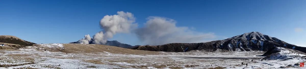
Timing your visit strategically improves both safety and scenery. Summer (June–August) brings vivid green grasslands and the best visibility for caldera panoramas. Winter turns the plateau gold and brown, occasionally dusted with snow, for a Mars-like landscape that photographers seek out specifically. Spring delivers the azalea bloom on the secondary peaks. Autumn fog can be unpredictable. Whatever the season, aim to arrive before 10:00 to beat both the large tour buses and the afternoon cloud that builds from midday onward.
How to Access Mt. Aso: Transport Options Compared
The most scenic way to reach the mountain from Kumamoto City is via the Aso Boy! limited express train on JR Kyushu. This tourist train features panoramic windows, puppy-themed decor, and family seating that makes the journey through rural Kyushu part of the experience. Seats fill quickly, so reserve in advance at Kumamoto Station or via the JR Kyushu app. The JR Pass covers the Aso Boy! fare, but seat reservation fees apply separately.
Standard local trains on the JR Hohi Main Line run more frequently and connect Kumamoto Station to Aso Station in about 70 minutes. You may need to transfer at Higo-Ozu Station depending on the specific service. Once at Aso Station, a dedicated shuttle bus runs to the Aso Volcano Museum and the crater area — the one-way fare is ¥500 and is not covered by any JR Pass. Factor this into your budget and carry cash, as the bus does not accept IC cards.
Renting a car provides the most flexibility for exploring the wider caldera and accessing remote viewpoints like Daikanbo. Driving allows you to stop at Komezuka, the Milk Road rim drive, and the Aso Farm Land without timing your day around bus schedules. Roads in the national park are well-maintained and well-signed in English. Parking is available at the Aso Volcano Museum (paid) and near Kusasenri. A car is the best option if you want to combine the volcano with the Kurokawa Onsen area on the same day.
If you are planning your transit connections from the city side, check our Kumamoto day trip itinerary for timing that works across all the main sights. Public buses also run from Kumamoto city center to the Aso region for a flat fare, though they run less frequently than the trains.
Planning Your Visit: Tours, JR Pass, and Accommodation
The Japan Rail Pass covers the JR Hohi Main Line and the Aso Boy! train, making the Aso region very cost-effective to include in a multi-city southern Japan trip. Reserve your Aso Boy! seats at any JR ticket window or via the JR Kyushu app as soon as your dates are confirmed — the tourist trains sell out on weekends and public holidays. Keep in mind the ¥500 bus fare from Aso Station to the crater is not included and must be paid separately in cash.
Several local companies run guided day tours from Kumamoto City that include transport, an English-speaking guide, and stops at Nakadake, the Aso Volcano Museum, and Kusasenri. These tours remove the bus-schedule complexity entirely and are worth considering if the crater access status is uncertain — guides can redirect to secondary peaks and viewpoints if the rim is closed on arrival. You can find options listed in any full Kumamoto itinerary designed for first-time visitors.
Staying in Aso City overnight rather than day-tripping from Kumamoto unlocks a different quality of experience. The large tour groups arrive mid-morning and leave by early afternoon — arriving the evening before and hitting the trailhead at 8:00 means you often have the volcano to yourself for the first hour. Traditional ryokans in Aso City use natural volcanic heat for their baths, which is a genuinely different sensation from the standard onsen. If you want to add a dedicated hot spring village, the Kurokawa Onsen day trip from Kumamoto pairs naturally with an Aso overnight before returning to the city.
Check the weather forecast two to three days before your visit for visibility conditions. Cloud often settles on the peaks from midday and completely obscures the crater by early afternoon. If the forecast shows morning cloud, consider swapping your Aso day with a city-based activity and visiting the volcano the next morning instead.
Exploring the Wider Aso-Kuju National Park
Beyond the smoking crater, the wider national park offers some of the most varied landscapes in Japan. Daikanbo is the most dramatic viewpoint, positioned on the northern caldera rim to give a full panoramic sweep of all five peaks. From this height the peaks of Aso arranged on the caldera floor resemble a reclining Buddha figure — a framing point that appears on virtually every map of the region. Access is by car or a short hike from the road, and it is the single best spot for photography of the entire caldera.
The Milk Road is a scenic driving route that runs along the northern caldera rim connecting Daikanbo to the grassland plateau. On clear days the road offers an unbroken view south across the entire caldera, with cattle grazing on the slopes below and volcanic plumes rising from Nakadake in the distance. Several rest stops along the route sell Aso dairy products — the soft cream here uses milk from caldera farms and tastes noticeably richer than standard Japanese soft-serve. This route is best driven in the morning before haze builds.
The Aso-Kuju National Park also borders several famous hot spring towns that are worth building into your itinerary. The Kurokawa Onsen day trip from Kumamoto connects naturally after a volcano day — the ryokan villages are about 40 minutes from Aso by car and offer a quiet, traditional alternative to the larger spa towns. Soaking in a rotenburo after a full day on volcanic slopes is a practical choice as much as a cultural one: the sulfur-rich waters help with muscle recovery.
For a broader two-day or three-day framework that includes the castle, the volcano, and the surrounding region, the Kumamoto 3-day adventure itinerary sequences the main sights in a logical order without retracing routes. The combination of Kumamoto's urban history and Aso's raw geology is the strongest argument for basing yourself in this city rather than treating it as a transit stop between Fukuoka and Kagoshima.
Frequently Asked Questions
Is Mount Aso currently open to visitors?
Access to Mount Aso depends on the current volcanic alert level and gas concentrations. While the caldera is always open, the Nakadake Crater rim may close during periods of high activity. Check the latest kumamoto highlights for status updates before planning your trip to the summit.
How do you get to Mount Aso from Kumamoto?
The easiest way is by taking a JR train from Kumamoto Station to Aso Station. From there, a local bus connects you to the Aso Volcano Museum and the crater area. The entire journey takes approximately ninety minutes to two hours depending on train connections.
Can you hike Mount Aso when the crater is closed?
Yes, you can often still hike secondary peaks like Mount Kishimadake or Eboshidake even if the main crater is restricted. These trails are located further from the active vent and offer safe alternatives. Always follow local signage and ranger instructions regarding trail safety and closures.
Is the JR Pass valid for travel to Mount Aso?
The JR Pass is fully valid for the trains between Kumamoto and Aso Station. However, it does not cover the local shuttle bus that travels from the station up the mountain. You will need to pay a separate fare for the bus or use a car.
Mount Aso is a powerful reminder of the geological forces that continue to shape the Japanese archipelago. From the smoking Nakadake Crater to the serene Kusasenri grasslands, the region offers an unforgettable experience. Planning your visit with safety and transport in mind ensures you make the most of this volcanic wonder.
After exploring the heights of the volcano, you can return to the city to see the visiting kumamoto castle reconstruction and history guide. Combining these two major landmarks provides a deep understanding of the nature and history of Kumamoto. The contrast between the ancient stone walls and the raw volcanic earth is truly striking.
Whether you choose to hike the highest peaks or enjoy a scenic train ride, Mount Aso will leave a lasting impression. Always remember to respect the volcanic environment and stay informed about current safety levels. We hope this guide helps you enjoy a safe and adventurous journey to one of Japan's greatest natural treasures.

 10 Essential Things to Know About BasashiMay 14, 2026