9 Best Hiroshima Hiking Trails and Scenic Walks (2026)
Explore the best Hiroshima hiking trails including Mt Misen, Mitaki Temple, and Sandankyo Gorge. Expert guide on trail difficulty, transport, and 2026 tips.
On this page
9 Best Hiroshima Hiking Trails and Scenic Walks
After my fourth trekking trip to the Chugoku region, I have come to see Hiroshima as a rare blend of coastal pilgrimage paths and rugged inland peaks. While most visitors stop at the Peace Memorial Park, the surrounding mountains offer a quieter, often spiritual perspective on the city's resilience. This guide walks through the best Hiroshima hiking trails, from Mt Misen and Mitaki-dera to Sandankyo Gorge, with the transport details, difficulty notes, and on-trail etiquette I wish someone had handed me on my first visit.
Last refreshed in early 2026 after a winter scouting trip, the schedules and prices below reflect current conditions. Most of these paths are surprisingly quiet even when the downtown area is busy with tourists, and many double as low-cost cultural routes through Shingon Buddhist sites associated with Kobo Daishi. See our roundup of top Hiroshima attractions to slot these hikes into a wider itinerary.
Free: The Hiroshima Essentials guide
Top things to do, where to stay, a perfect day plan, getting around, and the best time to go — a Hiroshima mini-guide you can take offline.
Why Hiroshima Is an Underrated Hiking Base
The geography of Hiroshima is defined by the Seto Inland Sea pressed against the Chugoku Mountains, which means you can summit a granite peak in the morning and eat fresh oysters on the coast by 4pm. Many trails were originally pilgrimage paths, so they are studded with mossy jizo statues, small shrines, and Buddhist carvings rather than blank ridgelines. Consult our seasonal activity guide to choose a month that matches your fitness and weather tolerance.
Variety is the other quiet selling point. You can pick between the steep, forested slopes of Miyajima, the emerald river ravine of Sandankyo, or the city-edge Peace Pagoda walk that ties straight back into the urban grid. Many travellers find these day hikes near Hiroshima a useful emotional reset after the heavier museum visits downtown. Air on the peaks is markedly cooler, which matters in a city where July humidity sits above 80%.
Hiking here is also cheap. Most trailheads are reachable on the JR West network or the Hiroshima streetcar for a few hundred yen, and almost every trail itself is free. Sturdy walking shoes handle every route in this guide, no technical gear required.
Hiroshima Trail Comparison at a Glance
Use this matrix to match your day to your energy and the season. Difficulty ratings reflect typical conditions for an average walker, not winter or wet-leaf conditions when stone steps turn slick. Times are one-way to the high point unless noted.
- Mt Misen via Daisho-in: 3.0 km, ~2 hours, moderate (2,000+ stone steps). Best for sea views over Itsukushima Shrine and the Seto Inland Sea.
- Mt Misen via Momijidani: 2.5 km, ~1.5–2 hours, moderate-steep. Best for autumn maple colours mid-to-late November.
- Mt Misen via Omoto: 3.2 km, ~2.5 hours, moderate. Best for solitude and rock formations; often quiet even in peak season.
- Mitaki-dera Falls Trail: ~2 km loop, ~1.5 hours, easy. Best for mossy temple atmosphere and autumn colour.
- Futabanosato / Peace Pagoda: ~2 km up, ~45 minutes, easy. Best for half-day visitors and city panoramas.
- Sandankyo Gorge: up to 13 km out-and-back, 4–5 hours full route, easy-moderate underfoot but long. Best for summer cool air and the seasonal ferry.
- Okunoshima Coastal Loop: ~4 km flat loop, ~1.5 hours, very easy. Best for a low-effort island day with rabbits and WWII ruins.
If you only have one day in the prefecture, Mt Misen via Daisho-in is the highest-payoff choice — it bundles the iconic floating torii views, the Reikado eternal flame, and a real summit ridge into a single afternoon.
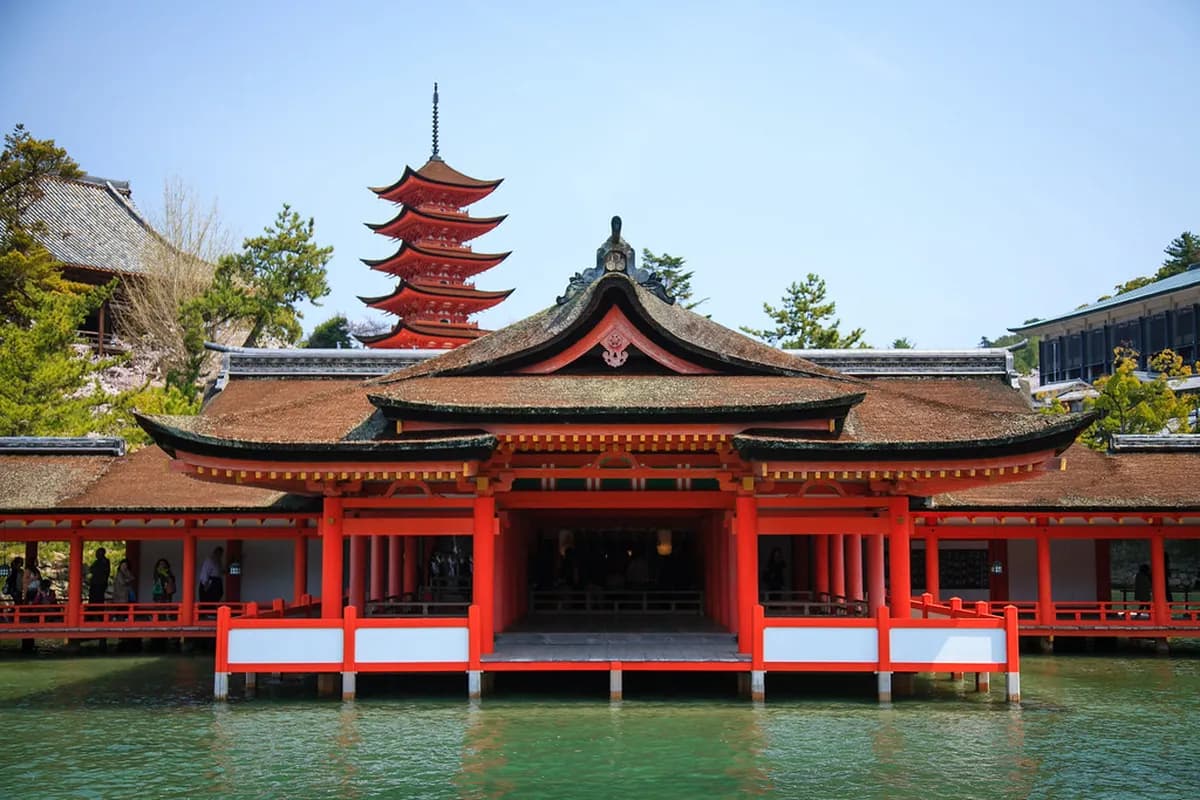
Mount Misen: The Sacred Peak of Miyajima Island
Mount Misen rises 535 metres above the western shore of Hiroshima Bay and is the spiritual heart of Miyajima (officially Itsukushima), which sits within the boundaries of Japan's Setonaikai National Park. Three hiking courses and a two-stage ropeway converge near the summit, where Reikado Hall houses an eternal flame said to have burned for over 1,200 years since Kobo Daishi (Kukai) lit it during his Shingon Buddhist training. The same flame was used to light the Flame of Peace in the Peace Memorial Park, tying the mountain directly to the city's modern story. Our dedicated guide on Mount Misen hiking routes has trail-specific maps and ropeway schedules.
The Daisho-in Course (3 km, ~2 hours) climbs more than 2,000 stone steps past Takinomiya Shrine and Shiraito Falls, and offers the best mid-trail view of the floating O-torii and Itsukushima Shrine. The Momijidani Course (2.5 km, ~1.5–2 hours) is the shortest and steepest, threading a maple-lined valley that turns brilliant red from mid-November. The Omoto Course (3.2 km, ~2.5 hours) starts at Omoto Shrine and passes the Iwaya Daishi Cave through a quieter fir forest. The two-segment ropeway runs 9:00–17:00 (round trip ¥1,800) and shaves about 80% of the ascent for visitors short on time, but you still have a 100-metre walk from Shishiiwa Station to the summit ridge.
How to get there: From Hiroshima Station, take the JR Sanyo Line to Miyajimaguchi (~30 minutes, ¥420, covered by JR Pass), then the JR ferry across to Miyajima (10 minutes, ¥200 one-way). All three trailheads are within a 10–25 minute walk from the ferry terminal.
The two-stage ropeway (¥1,800 round trip) runs 9:00–17:00. Walking up the Daisho-in course and riding the ropeway down gives you two completely different views of the Seto Inland Sea for the price of a one-way ¥1,000 ticket.
The 7 Wonders of Mt Misen: A Pilgrim's Checklist
Most Misen guides rush you to the summit and skip the spiritual landmarks scattered between the temple buildings near the top. The "7 Wonders" (Misen Nanafushigi) are a traditional checklist worth ticking off as you pass through Misen-honden Hall and the surrounding plateau, and they give the Daisho-in course a meaningful narrative beyond steps and views.
- Kiezu-no-hi (Eternal Flame): Housed in Reikado Hall, lit by Kobo Daishi roughly 1,200 years ago. The source of the Hiroshima Peace Park flame.
- Shakujo-no-ume (Plum of the Crosier): The ume tree that allegedly sprouted from Kobo Daishi's staff, near Reikado Hall. Locals watch it for blossom failures believed to foretell national misfortune.
- Kanman-iwa (Ebb and Flow Rock): A high-altitude rock pool whose water level mysteriously rises and falls with the tide far below.
- Mandara-iwa Rock: A large bedrock said to bear Sanskrit calligraphy from Kobo Daishi. Direct access has been closed since rockfalls; view from the marked overlook only.
- Sound of Wooden Clappers: A reported midnight sound attributed to Tengu, the long-nosed mountain goblin.
- Shigure-zakura (Showered Cherry): An Edo-period cherry tree that allegedly looked rain-soaked even in sunshine. Long gone, marked only by signage.
- Ryuto-no-sugi (Sea-Fire Cedar): A giant cedar said to be the source of mysterious lights seen from boats on the Inland Sea. Only the stump remains today.
Walking the Daisho-in course up and the ropeway down is the most efficient way to bag the wonders without doubling back, since most are clustered between Misen-honden Hall and the upper ropeway station.
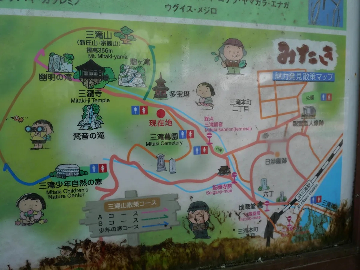
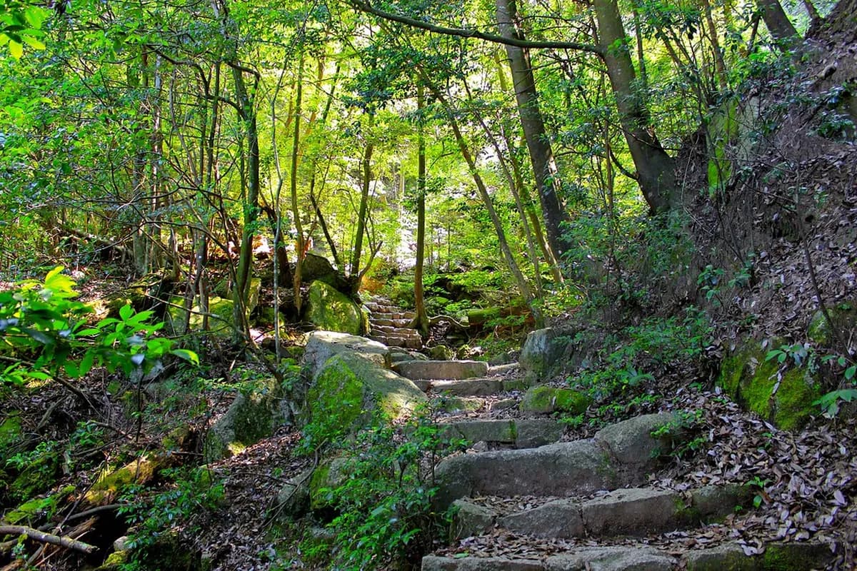
Mitaki-dera Temple: Three Waterfalls and Mossy Statues
Tucked into the wooded north side of Hiroshima, Mitaki-dera is the easiest atmospheric escape from the city. The temple takes its name from its three waterfalls, which feed a canyon dotted with hundreds of moss-covered jizo statues, a vermilion two-storey pagoda, and a tea house that pours matcha overlooking the lower falls. From the temple gate, two short trails climb roughly 1,200 feet to a summit clearing with picnic benches and city views; you can loop them rather than backtrack, and one descent passes through a striking bamboo grove.
The route is suitable for all ages and stays under 1.5 hours of walking total. It is at its best in late November when the maples redden, and on overcast days when the moss and stone glow under soft light. Temple grounds are free to enter and open daily 8:00–17:00; the small tea house charges around ¥500 for a bowl of matcha and a sweet.
How to get there: Take the JR Kabe Line from Hiroshima Station (Shinkansen exit, typically platforms 7 or 8) to Mitaki Station, about 10 minutes and ¥200, fully IC-card compatible (ICOCA, Suica, PASMO all work on the gates and ticket machines). From Mitaki Station, walk roughly 20 minutes northwest to the temple gate, following clear English signage.
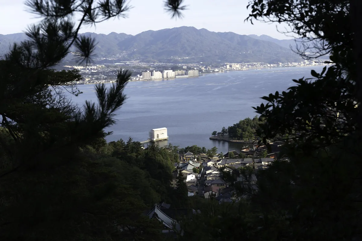
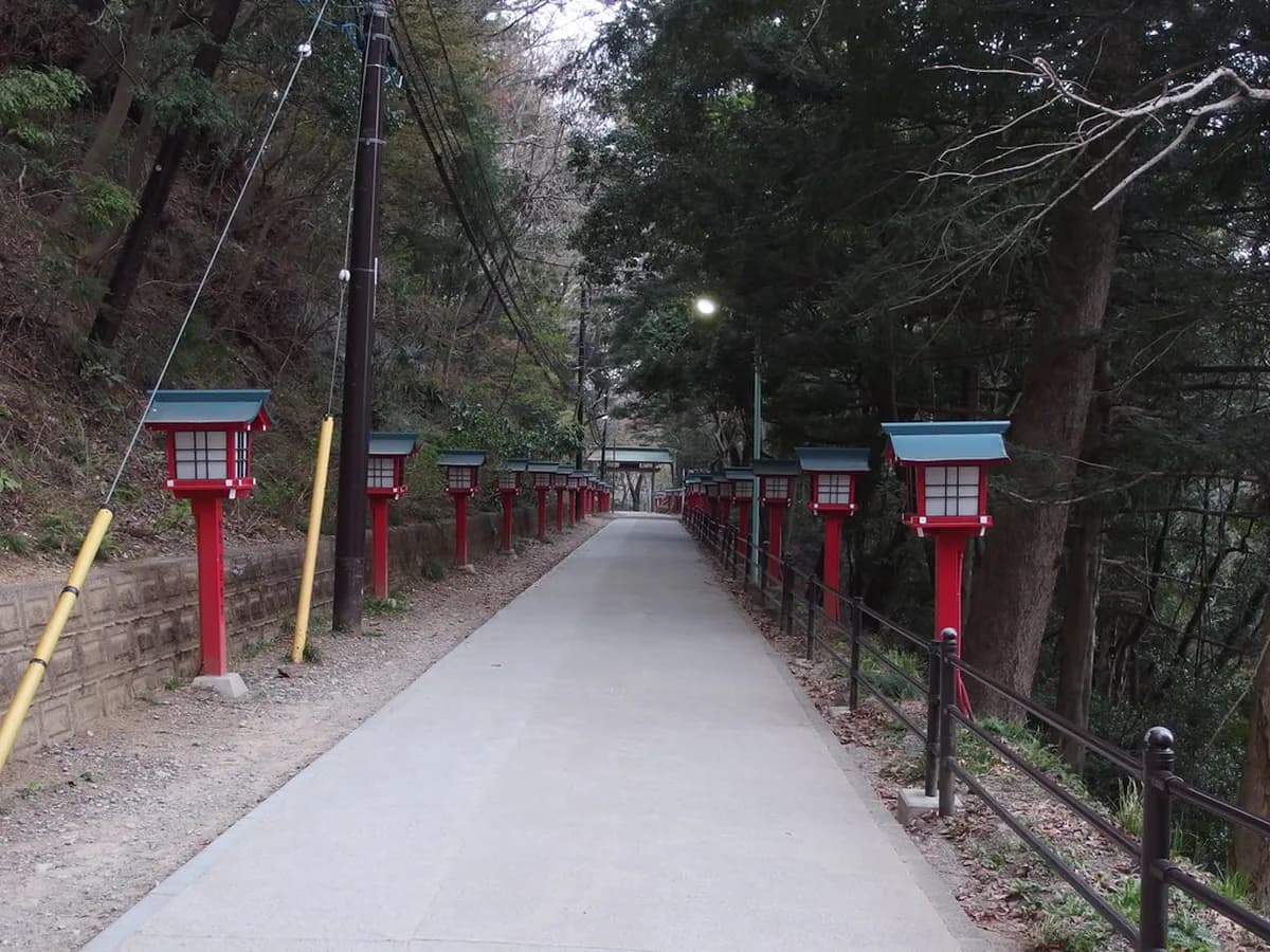
Mount Futaba: Toshogu Shrine and the Peace Pagoda
The 139-metre Mount Futaba sits directly behind Hiroshima Station, making it the easiest serious viewpoint in the city. The hike begins at Toshogu Shrine, climbs through a tunnel of about 120 vermilion torii gates, and ends at the dome-shaped Peace Pagoda — a Buddhist stupa that holds memorial stones for victims of the 1945 atomic bombing. About halfway up, a side staircase to the left reaches an observation point with a clear panorama over the delta and the Atomic Bomb Dome in the distance.
The full Futabanosato Historical Walking Trail extends roughly 6 km along the ridge and connects multiple shrines and small temples. For most visitors, the 45-minute climb to the Peace Pagoda and back is enough; pair it with a morning visit to the Peace Memorial Park for a meaningful contrast between memorial site and living mountain shrine.
How to get there: Walk 10 minutes north from Hiroshima Station's Shinkansen exit to Toshogu Shrine; the trail begins immediately behind it. Open at all hours, no entry fee, but the torii tunnel photographs best between 7:00 and 9:00 before tour groups arrive.
Sandankyo Gorge: Hiroshima's Emerald River Ravine
Sandankyo is a designated National Place of Scenic Beauty cut into the mountains north of the city, where a 13-kilometre gorge of emerald pools and waterfalls weaves between near-vertical cliffs. The full out-and-back is around 5 hours, but you can turn around at any of the named pools — Kurobuchi, Sarutobi, and Sandan-taki, the three-stage waterfall the gorge is named for. The walk itself is mostly flat and well-maintained; the difficulty is logistical rather than physical.
The signature experience is the small wooden ferry at Kurobuchi Pool, where a boatman poles you between the narrowest cliff walls. The boats run roughly April through November (typically suspended December–March, and after heavy rain), with a fare around ¥600–800 one-way in 2026. Autumn (mid-October to mid-November) brings the best colour; midsummer brings cool ravine air that runs 5–8°C below the city.
How to get there: Take the Hiroden Bus from platform 7 of the Hiroshima Bus Center to Sandankyo (about 80 minutes, ¥1,360 one-way; IC card accepted). Buses run only a handful of times daily — confirm the morning departure and the last return bus before you leave the city, because there is no late evening service. The bus center is on the third floor of the Sogo department store, a 5-minute walk from Kamiyacho-Higashi tram stop.
Okunoshima: The Rabbit Island Coastal Walk
Okunoshima is a flat 4-kilometre coastal loop you can finish in about 90 minutes, making it the lowest-effort walk on this list. The island is famous for the wild rabbits that descend from animals released after WWII, but the route is also a sobering history walk: ruined concrete buildings remain from the era when Okunoshima housed a secret poison gas plant, with bilingual interpretive signs along the path. The Poison Gas Museum near the ferry terminal (¥150) puts the ruins in context in about 20 minutes.
Bring rabbit pellets bought on the mainland, not human snacks; feeding bread or crisps is harmful and increasingly discouraged by signs around the island. The loop is best at sunset, when the rabbits are most active and the Inland Sea light turns gold over the bridge silhouettes of nearby Ikuchijima.
How to get there: Take the JR Sanyo Line / Kure Line to Tadanoumi Station (~1.5 hours from Hiroshima Station, ¥1,520, JR Pass valid), then walk 7 minutes to Tadanoumi Port. Ferries run hourly to Okunoshima in 12 minutes; round-trip is around ¥720 in 2026.
Mount Haigamine: Panoramic Views Over Kure and the Inland Sea
Mount Haigamine rises 737 metres above the naval port of Kure, southeast of Hiroshima city, and offers what locals consider the best 360-degree view of the Seto Inland Sea — chains of forested islands fading into the haze, with the Kure shipyards directly below. The summit observation deck is famously a "10-million-dollar night view" and stays open after dark, drawing photographers for the layered city lights.
The full hiking trail from the base is steep and takes about 2 hours up, 1.5 hours down. Less ambitious visitors can drive or take a city bus most of the way and walk only the final 20 minutes. Trekking poles are genuinely useful for the descent, where loose gravel and worn stone make slips common.
How to get there: Take the JR Kure Line from Hiroshima Station to Kure Station (~35 minutes, ¥510). From there, take a local Hiroden bus toward Haigamine; the trailhead bus stop is signposted in English. For sunset, time the ride to arrive at the summit around 30 minutes before dusk.
Pairing Trails With Tides and Ropeways: A Local's Logistics Hack
The most useful piece of planning advice for Mt Misen does not appear in any of the standard listicles. The classic "iconic" Miyajima image — the floating torii framed by the bay from above — only works at high tide, and Hiroshima Bay swings several metres twice a day. Check the Miyajima tide table the night before, then plan to be on the upper Daisho-in course or near the summit ropeway station within 90 minutes of high tide. You will get the floating torii from above and the floating shrine from below in a single visit; mistime it and the bay drains to mudflats.
The second logistics hack is asymmetric trail use. Walking up the Daisho-in course (best mid-trail views) and riding the ropeway down (best aerial panorama of the Seto Inland Sea over treetops) is faster, easier on the knees, and gives you two completely different perspectives for the price of one ¥1,000 one-way ropeway ticket. The reverse — ropeway up, hike down — is also valid for travellers worried about the climb but who still want the temple sequence on the descent. Either pairing is dramatically better than a there-and-back hike on the same trail.
For Mitaki-dera and the Peace Pagoda, the timing trick is light rather than tide: Mitaki photographs best on overcast days when moss saturates and the pagoda reds glow, while the Peace Pagoda viewpoint depends on clear morning air before the city haze rises. Building one rainy-day trail and one bluebird-day trail into your itinerary keeps weather from killing your only chance.
Essential Hiroshima Hiking Etiquette and Logistics
Most trailheads are reachable on JR Kabe, JR Sanyo, or JR Kure lines from Hiroshima Station, and all three are fully IC-card compatible — ICOCA, Suica, and PASMO tap through the same gates. Top up your card with at least ¥3,000 for a full hiking day. The Kabe Line for Mitaki typically leaves from platforms 7 or 8 at Hiroshima Station; the Sanyo Line for Miyajimaguchi leaves from platforms 1–4. Highway buses for Sandankyo leave from the Hiroshima Bus Center, not the station — confirm the morning and last-return departures before committing. Our local transport guide covers tram, bus, and JR transfers in more depth.
Etiquette in Hiroshima draws a clear line between trail manners and shrine manners, and locals notice when visitors confuse them. On a temple approach (Mitaki-dera, Daisho-in, Toshogu), bow lightly when passing under the first torii gate, walk to the side rather than the centre of the path (the centre is reserved for the kami), and keep voices low — monks and worshippers are often performing rituals in earshot. On the trail itself, a friendly "konnichiwa" or "ohayo gozaimasu" is the norm with everyone you pass; uphill hikers have right-of-way at narrow passes; pack out all rubbish because trail bins are essentially nonexistent on Misen, Mitaki, and Sandankyo.
Wildlife safety is genuine, not theatrical. Wild boar (inoshishi) roam the lower Misen slopes and occasionally Mitaki — never approach, never offer food, back away slowly without turning your back, and keep dogs leashed. Bears are present in the Sandankyo area; clip a small bear bell to your pack and avoid hiking alone at dawn or dusk. Humidity is the underrated danger: carry at least 2 litres of water even for the city-side walks, because vending machines disappear once you leave the trailhead.
Wild boar roam the lower Misen slopes and the Mitaki-dera area. Never approach or feed them — back away slowly. For Sandankyo, attach a bear bell to your pack and avoid the gorge alone at dawn or dusk.
How Many Days Do You Need for Hiroshima Hiking?
One day is enough if you focus exclusively on Miyajima: ferry across after breakfast, climb Daisho-in, descend by ropeway, and pair the route with the floating torii and Itsukushima Shrine before the last ferry back. Our Miyajima visitor guide has full ferry timings and tide windows.
Three days is the ideal window. Day one for Misen, day two for Mitaki-dera in the morning and Toshogu / Peace Pagoda in the afternoon, day three for Sandankyo Gorge or Okunoshima depending on season. Active travellers can layer the Nagarekawa food district into their evenings without losing recovery time, since central Hiroshima is compact enough to return to your hotel between activities. For travellers building a wider itinerary on a budget, our Hiroshima budget travel guide covers cheap eats and free sights to fill in around the hikes.
Schedule weather-dependent trails first. Granite steps on Mt Misen are slick when wet; save Mitaki and indoor museums for forecast rain. Expect peak autumn colour mid-to-late November — see our Hiroshima autumn colours guide for exact week-by-week predictions in 2026.
Frequently Asked Questions
How do I get to Mount Misen from Hiroshima Station?
Take the JR Sanyo Line to Miyajimaguchi Station, then board the ferry to the island. From the ferry pier, walk about 15 minutes to reach the Daisho-in or Momijidani trailheads. The total travel time is roughly one hour.
Which Mount Misen trail is the easiest for beginners?
The Momijidani Course is the most straightforward route for beginners. It features a gentler incline through the forest and takes about 90 minutes. For the least effort, you can take the ropeway up and walk the final 20 minutes.
Is Mitaki Temple free to visit?
Yes, entrance to the Mitaki-dera Temple grounds and its hiking trails is free. The temple is located a short walk from the JR Mitaki Station on the Kabe Line. It is open daily from 8am to 5pm.
Hiking in Hiroshima is more than exercise — it is a way to walk the spiritual and natural backbone of the Chugoku region, from the eternal flame of Mt Misen to the mossy waterfalls of Mitaki-dera and the emerald pools of Sandankyo. Pack sturdy shoes, a topped-up IC card, and at least two litres of water, and treat at least one of these peaks as a non-negotiable in your 2026 itinerary. The view of the sun setting over the Seto Inland Sea from a quiet summit is the kind of memory that reframes the whole trip.
Free: The Hiroshima Essentials guide
Top things to do, where to stay, a perfect day plan, getting around, and the best time to go — a Hiroshima mini-guide you can take offline.
You might also like


Continue reading
More guides you'll find useful