Mikurigaike Pond Visitor Guide: Your Essential 1-Day Alpine Route Itinerary
Mikurigaike Pond sits at 2,405 metres on the Murodo Plateau, the highest point of the Tateyama Kurobe Alpine Route. It is the largest volcanic crater lake in the Northern Japanese Alps, and on a clear, calm morning its deep blue surface mirrors the jagged peaks of Mount Tateyama with near-perfect clarity. This guide covers everything you need to plan a day trip focused on the pond: a step-by-step itinerary with transport legs and timings, ticketing options with current prices, what to pack, and the secondary sights around the loop that most visitors miss.
Mikurigaike Pond: An Introduction to the Northern Alps Gem
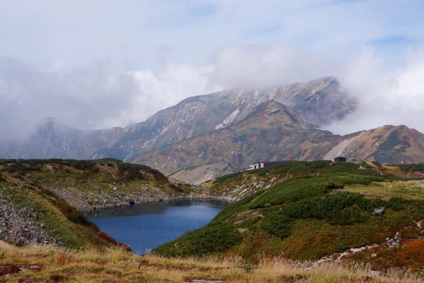
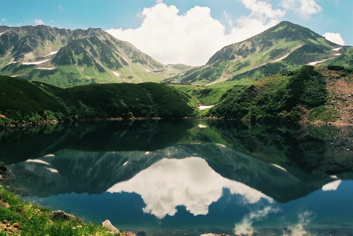
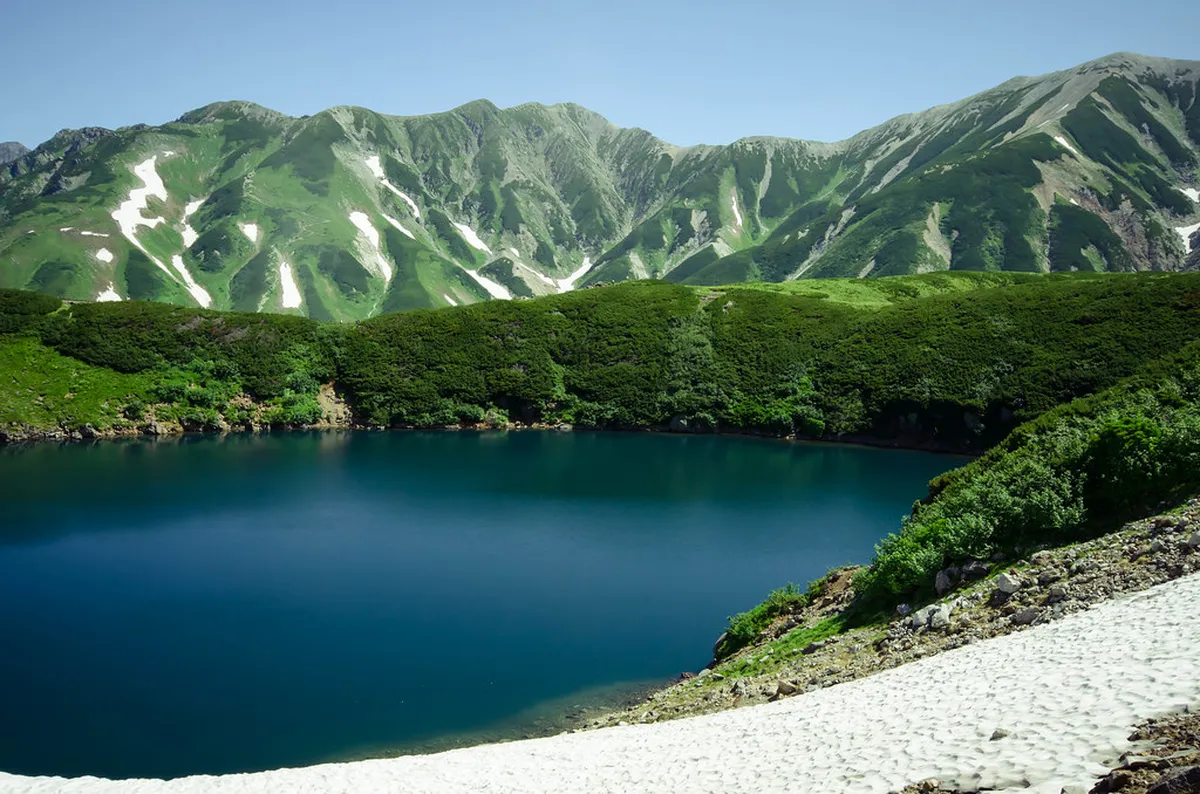
Mikurigaike is a volcanic lake formed in a caldera and later filled by rainwater and snowmelt. At 2,405 metres above sea level it is one of Japan's highest bodies of water, and its depth and volcanic chemistry give it an unusually vivid blue-green colour. The pond stays frozen for much of the year and typically becomes fully accessible from late June, though you can reach its edges earlier on snow-covered paths in May and early June.

The surrounding area belongs to the Tateyama Kurobe Alpine Route, a 37-kilometre mountain crossing that uses five modes of transport — train, cable car, bus, ropeway, and trolley — to traverse the Japan Alps between Toyama Prefecture and Nagano Prefecture. Murodo Terminal, where you alight to walk to Mikurigaike, is five to ten minutes on foot from the pond. The trail is well maintained and mostly flat.
Mikurigaike is also home to the Japanese fire-bellied newt (a protected species) and the raicho, the rock ptarmigan that serves as the symbol of the Tateyama mountains. The birds are remarkably unafraid of people and can often be spotted along the pond trail in the early morning.
Why Mikurigaike Pond is a Must-See on the Alpine Route
Most stops on the Alpine Route are transit points — you admire a view and reboard. Mikurigaike is different. A well-maintained trail circles the lake and takes about 40 minutes to complete at a relaxed pace, making it one of the few places on the route where you genuinely slow down. It is an accessible walk for all fitness levels; the path is largely flat, stone-lined in drier sections and boardwalked over wetland areas.
The pond is at its photographic best in the morning before wind ripples the surface. The best reflections of Mount Tateyama appear from late June through October, when the ice has melted completely. Autumn is particularly dramatic — the surrounding plateau turns amber and gold from late September through mid-October, and the colour frames the water on three sides.
The pond also connects directly to the Murodo area's other hiking trails, so it works as the starting point for a longer loop that takes in Jigokudani (Hell Valley) and the lesser-known secondary ponds on the plateau. See the section below on what to expect from those trails before you commit to them.
Planning Your Visit: Best Time to Experience Mikurigaike Pond
The Alpine Route operates from around 15 April to 30 November each year, though exact opening dates shift slightly and should be confirmed on the official Tateyama Kurobe Alpine Route website before booking. Each season offers a distinct experience at the pond.
Mid-April to late June is snow season. The iconic Snow Wall (Yuki-no-Otani) near Murodo can reach 20 metres high in April, making this the busiest and most booked-out period. The pond itself may still be partially frozen in May. Book tickets weeks in advance if you want this window. Late June to early September gives you the clearest water and best reflection conditions, with the plateau fully thawed and alpine wildflowers in bloom. Late September to mid-October is the autumn foliage peak — the most visually dramatic time to visit and less crowded than the snow-wall period. November sees closing preparations; some segments may run reduced schedules.
Regardless of season, arrive at Murodo before 10:00 or after 15:00 if you want a quieter pond circuit. Weekdays are noticeably calmer than weekends. Check the Alpine Route climate page for season-by-season temperature and clothing guidance — Murodo regularly runs 10–15 °C cooler than Toyama city even in midsummer.
Your Mikurigaike Pond Day Trip Itinerary (via Tateyama Kurobe Alpine Route)
This itinerary runs west to east — Toyama side to Nagano side — starting from Dentetsu-Toyama Station. The full one-way traverse takes 8–9 hours including transfers and time at each stop. Start before 09:00 to avoid the peak cable-car queue at Tateyama and to reach Murodo while the pond reflections are still calm.
- 07:46 — Arrive Toyama. If coming from Kanazawa, the Hokuriku Shinkansen reaches Toyama in around 20 minutes. Change to Dentetsu-Toyama Station (2-minute walk to the left as you exit the JR building). Pick up your pre-purchased Alpine Route ticket here, or buy one at the Tateyama Kurobe counter in Dentetsu Station. If you want your luggage forwarded to Shinano-Omachi, arrange it at the luggage counter near the platforms; the service costs ¥2,500.
- 08:13 — Dentetsu Toyama → Tateyama Station (train, included in Alpine Route ticket, ~66 min). The Toyama Chiho Railway passes through rice paddies and small towns before climbing into the foothills. Arrive Tateyama around 09:19.
- 09:40 — Tateyama → Bijodaira (cable car, ~7 min, included in ticket). Join the queue immediately on arrival at Tateyama — it builds fast. The car is steep and usually packed; you likely will not see much out of the windows on this leg.
- 10:20 — Bijodaira → Midagahara (bus, ~30 min). At Bijodaira you can choose an express bus directly to Murodo or a local bus via Midagahara. The local bus is worth taking: Midagahara is a boardwalk wetland at 2,000 metres with almost no crowds. The short loop is 1 km (40 minutes); the outer loop is 2.1 km (about 80 minutes). Before hiking, go inside the terminal building and reserve a seat on the next bus to Murodo — buses depart every 40 minutes and the staff are firm about reservations.
- 12:10 — Midagahara → Murodo (bus, ~20 min). Sit on the left side of the bus for the best views of the valley and surrounding peaks on the climb to Murodo.
- 12:30 — Murodo Terminal. The pond loop (600 m direct walk to the pond, or the full 1.7 km circuit) takes 40–60 minutes at a leisurely pace. Lunch at one of the restaurants inside the terminal costs roughly ¥1,000–¥2,000. If time allows, extend your stay for the Raichozawa trail (2.4 km, 2.5 hours) or to visit Mikurigaike Onsen.
- 14:15 — Murodo → Daikanbo (trolley bus through Mount Tateyama tunnel, ~10 min). The trolley departs frequently; last departure is around 16:30 depending on the season — check the timetable the morning of your trip.
- 14:40 — Daikanbo → Kurobedaira (ropeway, ~7 min). The ropeway has excellent views of the Kurobe valley and the lake formed behind Kurobe Dam.
- 15:00 — Kurobedaira → Kurobeko (cable car, ~5 min). Another crowded but short leg.
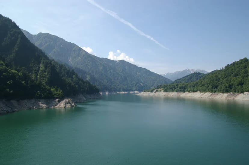
- 15:35 — Walk across Kurobe Dam (free, ~15 min). Japan's tallest arch dam, built 1956–1963, with views of the emerald reservoir on one side and the valley on the other.
- 16:00 — Kurobe Dam → Ogizawa (trolley bus through tunnel, ~15 min). Then bus to Shinano-Omachi (~35 min), arriving around 16:35. From Shinano-Omachi, trains run to Matsumoto (1 hr) and onward to Nagano or Tokyo.
The total active time at Murodo — including the Mikurigaike pond walk — is roughly 90 minutes if you skip Midagahara, or around 60 minutes if you add the Midagahara wetlands stop. If the pond and its surroundings are your priority, skip Midagahara and take the express bus directly to Murodo from Bijodaira; you will arrive closer to 11:00 and have over two hours before you need to board the Daikanbo trolley.
Beyond Mikurigaike: Secondary Ponds and the Jigokudani Trail Reality
The Murodo plateau has several volcanic ponds within short walking distance of the terminal, but most visitor guides focus only on Mikurigaike. If you extend the loop, you will pass Midorigaike — a smaller pond ringed with wildflowers and, on clear days, a clean reflection of Tateyama's lower ridgeline. It is quieter than Mikurigaike and worth the extra five minutes of walking.
You may also spot the Chinoike (Blood Ponds) — small reddish pools coloured by iron oxide deposits from the volcanic ground. The sulfur smell is strong near these ponds and the surrounding trail section. If the smell becomes pervasive, turn back; the gases that colour the water can also cause dizziness on still days.
Jigokudani (Hell Valley) is visible from above and the steam vents make for striking photographs, but note that the trail through the valley is frequently closed due to high volcanic gas concentrations. You can look down into the fumaroles from the loop trail, but do not expect to walk through the valley floor itself. Check current trail conditions at the Murodo information desk on arrival — closures are common and are not always reflected on pre-trip maps or apps.
Mikurigaike Onsen, Japan's highest hot spring inn, is adjacent to the trail just past Jigokudani. It accepts day visitors (¥800 per person as of 2026; confirm on arrival), making it a logical final stop before returning to the terminal. The combination of the pond loop, secondary ponds, and a 20-minute soak at the onsen fits comfortably within a 2-hour Murodo window.
How to Buy Tickets for the Tateyama Kurobe Alpine Route
The Alpine Route is not covered by the standard JR Pass. A one-way ticket from Dentetsu-Toyama Station to Shinano-Omachi costs approximately ¥13,820 (around US$97) for adults and ¥6,930 (around US$49) for children as of 2026 — verify current prices on the official ticketing page. There are three realistic ways to buy.
Online in advance. Buy through the Alpine Route website before arriving in Japan. During peak season (April–June, when the Snow Wall draws large crowds), slots for popular morning departures sell out weeks ahead. Register on the site, choose your start point and time slot, then collect the physical ticket at a WEB ticket counter at least 15 minutes before departure. Same-day at the station. Tickets go on sale at Tateyama Station 20 minutes before the first departure and at Ogizawa 40 minutes before the first departure. Queues for early-morning slots can be very long. Arrive at least 30 minutes before ticket sales open if you need a specific time. JR Alpine-Takayama-Matsumoto Area Pass. This 5-day regional pass covers the Alpine Route crossing plus JR trains between Nagoya, Toyama, and Shinano-Omachi. The adult price runs approximately US$150.20 (valid until 30 September) and US$108.00 from 1 October — check the current rate at purchase. If your trip already includes Nagoya and Matsumoto, this pass can be better value than buying the Alpine Route ticket alone.
Whichever option you choose, you still need to collect a physical ticket and — during busy periods — reserve your cable-car slot on the day. The cable car queue at Tateyama fills fastest; being there when the gates open gives you the best chance of boarding the first departure.
Essential Packing & Preparation for Mikurigaike Pond
Murodo's weather is unpredictable at any time of year. Even on a warm summer day in Toyama, the plateau at 2,450 metres can be windy and cold, and cloud cover can roll in within minutes. Dress in layers. A mid-layer fleece and a waterproof, windproof outer shell are non-negotiable even in August. Temperatures at Murodo in July–August typically range from 10 °C to 18 °C; in May they can drop below 0 °C with wind chill.
Footwear matters on the pond loop. The trail is well maintained but sections can be wet, uneven, or snow-covered in spring. Sturdy trainers with ankle support or light hiking boots are enough for the main circuit. If you plan the Raichozawa trail or the Mount Tateyama summit hike, proper hiking boots are advisable. Buy snacks and any convenience-store items in Toyama or Tateyama before departure — food options at Murodo are limited to the terminal restaurants and a couple of outdoor stalls, and prices are higher at altitude.
For photography, a polarising filter significantly reduces surface glare and deepens the colour of Mikurigaike's water. Pack a portable charger: cold temperatures drain camera and phone batteries faster than usual. UV protection is strong above 2,000 metres even on overcast days, so sunscreen and sunglasses are worth bringing regardless of the forecast.
Insider Tips for a Memorable Mikurigaike Pond Experience
Start earlier than you think you need to. The cable car at Tateyama fills quickly, and if you miss the first or second departure you lose time at Murodo. Being on the 09:40 cable car — or earlier — means you reach Murodo by midday when reflections are still calm and the main trails are not yet at peak congestion.
On the bus from Midagahara to Murodo, sit on the left side. That leg offers the most dramatic valley and peak views of the entire Alpine Route, and the right side of the bus faces a slope rather than the open valley. It is a small detail that is easy to overlook when boarding in a crowd.
If you want to see raicho (rock ptarmigan), scan the rocks and low scrub near the pond trail between 07:00 and 10:00. The Murodo area supports a population of around 350 birds and they are not shy, but they tend to move away from the trail once heavy foot traffic begins. Earlier visits during the autumn migration window (September–October) also increase your chances of a sighting.
For the best reflections, a windless morning is the critical factor — not just the season. Check the Murodo weather forecast the evening before; a calm morning with partial cloud actually produces richer colours in the water than a completely cloudless sky, because the blue tone dominates less and the surrounding mountain contours come through more clearly.
Frequently Asked Questions About Visiting Mikurigaike Pond
Below are the questions most commonly asked about planning a Mikurigaike visit in 2026.
Can you do the Alpine Route in one day? Yes. The full one-way traverse from Dentetsu-Toyama to Shinano-Omachi takes 8–9 hours including transfers, stops, and a reasonable amount of time at Murodo. Starting before 09:00 from Toyama is the key constraint. A round-trip (returning to the same side) is not practical in a single day.
Is the Tateyama Kurobe Alpine Route worth the cost? For most visitors, yes. The combination of high-altitude scenery, five different transport types, and accessible alpine hiking — including the Mikurigaike loop — is genuinely unlike any other route in Japan. The cost is significant (roughly ¥13,820 one-way for an adult in 2026), so plan around the specific season and sights that matter most to you rather than doing it as a general "tick."
Can I drive the Alpine Route? No. Private vehicles are prohibited on the main Alpine Route section. You must use the designated public transport. Park your car at Tateyama Station or Ogizawa Station. If you are traversing one-way and need your car at the other end, a vehicle forwarding service operates for a fee — check the official route website for current pricing and booking procedures.
Exploring Beyond Mikurigaike: Nearby Attractions & Accommodation
Within the Murodo area, the Yuki-no-Otani Snow Wall is the other major draw. It runs roughly 500 metres alongside the road near the terminal and is accessible from mid-April to late June. At its peak in April it can exceed 20 metres in height on both sides of the walkway. If the Snow Wall is a priority, book the April–May window — and book tickets early. The Kurobe Dam, at the eastern end of the route, offers a completely different experience: an engineered landmark with viewing platforms and seasonal water discharge displays.
For accommodation, the two in-route options closest to Mikurigaike are Hotel Tateyama (inside Murodo Terminal, pricy but unrivalled for early-morning access) and Midagahara Hotel (2,000 metres, a step below Murodo, good value and notably quieter). Staying overnight at either location lets you experience the pond at dawn — before any day-trippers arrive — which is worth far more than any gear upgrade for photography. Book both well in advance for peak season. If you prefer a base in a town, Toyama and Omachi both offer a wide range of hotels at city prices, with the Alpine Route accessible on the same morning.
For further context on the wider Tateyama Kurobe Alpine Route and the Daikanbo observation platform, see the dedicated pages on this site.
Frequently Asked Questions
Can you do the Tateyama Kurobe Alpine Route in one day?
Yes, traversing the entire Tateyama Kurobe Alpine Route in one day is possible. It typically takes 8-9 hours one-way, including transfers. Starting early is essential to complete the journey comfortably. We recommend checking the official timetable for specific operating hours.
How do I get to Mikurigaike Onsen?
Mikurigaike Onsen is located a short walk from Murodo Terminal. Once at Murodo, follow the signs towards Mikurigaike Pond. The onsen is situated near the pond itself. Access is usually straightforward for visitors to the area.
Is the Tateyama Kurobe Alpine Route worth it?
Many travelers find the Tateyama Kurobe Alpine Route to be a truly worthwhile experience. It offers unique mountain scenery, diverse transport methods, and iconic natural attractions. The cost is significant, but the unforgettable views often justify the expense. We believe it offers excellent value for nature enthusiasts.
Can I drive the Tateyama Kurobe Alpine Route?
No, private cars are not permitted on the main section of the Tateyama Kurobe Alpine Route. You must use the designated public transport system. This includes cable cars, buses, and ropeways. You can park your car at either Tateyama Station or Ogizawa Station. A car forwarding service is available for a fee if you traverse the route one-way.
Mikurigaike Pond rewards careful timing more than any other stop on the Alpine Route. Get to Murodo early, walk the loop before the midday crowds arrive, and allow time for the quieter secondary ponds and the onsen on the way back to the terminal. The itinerary above gives you a workable framework — adjust it by season and by how much time you want at altitude versus on the transport legs. The pond is the centrepiece, but the plateau around it has more depth than a single circuit reveals.
For official details, visit the Mikurigaike Pond on Wikipedia and Mikurigaike Pond official site.