Taisho Pond Visitor Guide & Kamikochi Itinerary (2026)
Taisho Pond (大正池) is the first major sight most visitors encounter on entering Kamikochi — a still, wide expanse of water where dead trees stand rooted in the shallows and Mount Hotaka and Mount Yake reflect off the surface on calm mornings. The pond formed in 1915 when Yake-dake erupted and dammed the Azusa River. More than a century later, the standing deadwood is slowly eroding, making each visit slightly different from the last.
This guide covers how to reach Taisho Pond, how the walking route to Kappa Bridge unfolds, what to expect on the trail in 2026, and the practical details — bus fares, gear, seasonal timing — that will make or break your day in the valley.
Planning Your Visit to Taisho Pond & Kamikochi
Kamikochi is open from mid-April to mid-November. In 2026, the Kama Tunnel gate lifted on April 17 and the season runs through November 15. Outside those dates, the access roads are closed by snow and all facilities shut down. Check the official Kamikochi website before booking transport — dates can shift by a few days depending on weather.
Private vehicles are banned beyond designated parking areas. Everyone enters by bus, which is exactly why the valley stays as quiet as it does. A day trip is realistic: the core walk from Taisho Pond to Kappa Bridge is 3.5 km of flat trail, takes about an hour, and leaves time for slow stops and photos. Allow 4–6 hours total in the valley. If you want to continue to Myojin Pond, plan for 5–7 hours or stay overnight.
One important 2026 update: all buses on the Matsumoto–Kamikochi route now require advance reservations. This rule started in 2025 and continues this season. You cannot simply show up and buy a ticket. Book through japanbusonline.com, ideally at least a month ahead for weekends and any dates in October.
Getting to Taisho Pond: Transportation Guide
From Matsumoto, the standard route combines two services. Take the Matsumoto Electric Railway from Matsumoto Station to Shin-Shimashima Station (30 min, ¥710 — cash only, no IC cards at JR Matsumoto), then transfer to an Alpico bus to Kamikochi Bus Terminal (65 min, ¥3,100). Buses run 7–17 times daily depending on the season. Direct buses from Matsumoto Bus Terminal also operate: the 05:30 departure costs ¥5,000 and the 10:15 costs ¥4,600. Both require reservations.
From Takayama, take a Nohi Bus to Hirayu Onsen (60 min, ¥1,570), then a shuttle bus to Kamikochi (25 min, ¥1,160). The Hirayu shuttle runs roughly every 30 minutes and does not require a reservation — this is the most flexible entry point if you prefer not to book ahead. Parking at Sawando costs ¥800/day in 2026 (up from previous years); the shuttle from Sawando to Kamikochi takes about 30 minutes.
From Tokyo (Shinjuku), direct highway buses depart at 07:15 and 10:25 PM (overnight). Journey time is around 4 hours 47 minutes; fares range ¥8,000–¥14,000 depending on date and bus type. Reservation is required. Most visitors from Tokyo go via Matsumoto on the Shinkansen to Nagano, then the Shinonoi Line to Matsumoto, before connecting to the Kamikochi buses — total journey around 3.5 hours from Tokyo Station.
Once inside the valley, buses stop at Taisho Pond (大正池バス停) before the main Kamikochi Bus Terminal. Ask to be let off at Taisho Pond if you want to start the walk from the southern end — the driver will stop there on request.
Arriving at Taisho Pond (大正池)
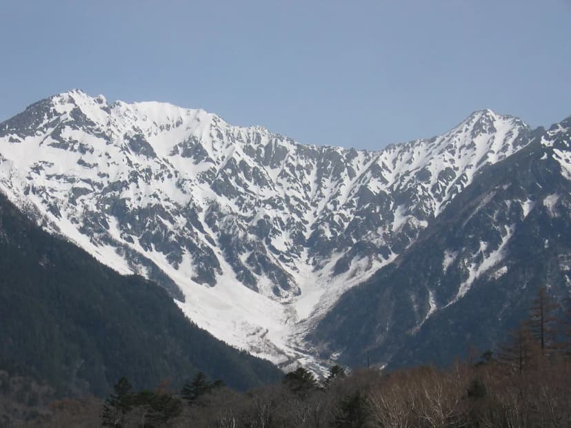
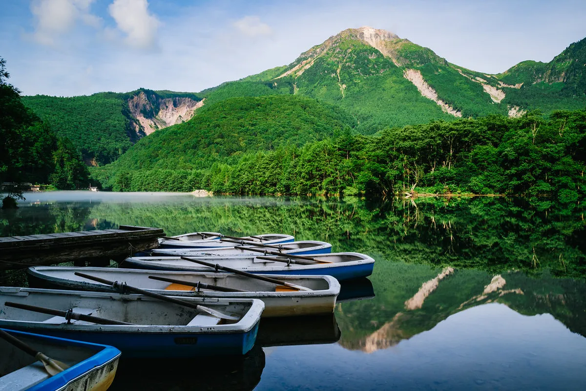
The bus drops you a short walk from the pond's southern bank. The first view is wide and open: a broad, shallow lake surrounded by forest and mountain walls, with the dead tree trunks rising from the water at irregular intervals. The surrounding peaks — Mount Hotaka (3,190 m) to the north, Yake-dake to the southwest — fill the sky above the treeline.
Early morning is when the pond earns its reputation. Before 09:00, mist rises off the water and gathers around the base of Yake-dake. The dead trees become silhouettes. By 10:00, the mist clears and the mood shifts from atmospheric to straightforwardly beautiful. If you are day-tripping, you will almost certainly arrive after the mist has gone — that is the honest trade-off of not staying overnight.
There are benches along the southern shore for sitting and photographing. The pond itself has no entry fee; it is part of Chubu Sangaku National Park. Public toilets are located near the bus stop. This is a good place to drink water and orient yourself before heading north toward Kappa Bridge.
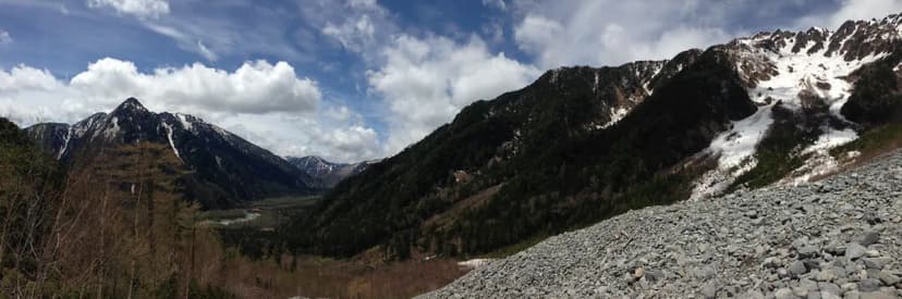
The Trail from Taisho Pond to Tashiro Wetland
From the pond, the trail follows the right bank of the Azusa River northeast. The first section passes through dense forest — Japanese larch and white birch, moss-covered ground, the sound of water under wooden boardwalks. The light here filters green through the canopy, and the temperature drops noticeably under the trees. This stretch gets less attention than Kappa Bridge, but it is where the valley feels most alive.
A practical note for 2026: the Nature Trail boardwalk on the forest course between Taisho Pond and Tashiro Wetland remains closed due to deteriorating wooden paths. The main riverside trail is open and well-maintained, but if you were planning to take the boardwalk route specifically, that section is unavailable this season. Follow the main trail signs rather than the boardwalk markers.
About 25 minutes from Taisho Pond, the forest opens into Tashiro Wetland — a wide, marshy clearing with unobstructed mountain views. In June, cotton-grass and azaleas bloom across the marsh. In autumn, the grasses turn amber against dark conifers. Tashiro Bridge (田代橋) crosses the river here; crossing it and continuing on the east bank leads you toward Kappa Bridge. The walk from Taisho Pond to Tashiro Bridge takes roughly 30–40 minutes at a relaxed pace.
Continuing to Kappa Bridge: What to Expect
From Tashiro Wetland, the trail continues north along the river for another 20–25 minutes to Kappa Bridge (河童橋). The full walk from Taisho Pond to Kappa Bridge covers about 3.5 km and takes 60–90 minutes at a relaxed pace. The terrain is flat throughout: a mix of paved walkways, gravel trail, and short boardwalk sections. No elevation gain. Suitable for most fitness levels, including families with older children.
Kappa Bridge is a 36-metre wooden suspension bridge spanning the Azusa River. It is the most photographed spot in Kamikochi — upstream, the Hotaka peaks fill the frame; downstream, Yake-dake anchors the view. The original bridge was built in 1891; the current structure dates from 1997. A visitor center (free, open 08:00–17:00) sits near the bridge, along with public toilets, souvenir shops, and the main cluster of dining options. Meals at the cafes and restaurants around Kappa Bridge typically run ¥1,500–¥2,500.
The Kamikochi Bus Terminal is a 6-minute walk from Kappa Bridge. If you started from the Taisho Pond bus stop and walked the full route, you finish here and catch your return bus. Book your return bus in advance — especially on weekends and in October — because buses fill up and there is no backup option once the last service departs.
Starting from Kappa Bridge: The Reverse Route
Some visitors arrive at Kamikochi Bus Terminal first and walk south to Taisho Pond, then return to the terminal. This is the route described by most first-timer guides, and it works well. From the terminal, walk 6 minutes to Kappa Bridge, then follow the river south. The distance is the same 3.5 km; the walk takes about an hour. Round trip to Taisho Pond and back is 2–2.5 hours.
The trade-off versus starting from Taisho Pond: you walk the route in reverse, meaning you arrive at Taisho Pond already an hour into your day rather than fresh off the bus. The stronger approach — if buses permit — is to get off at the Taisho Pond stop, walk the full route north to Kappa Bridge, and board the return bus from the terminal. One direction, no backtracking, and the landscape unfolds chronologically from the wide volcanic pond through the forest and wetland to the alpine panorama at the bridge.
Best Time to Visit Taisho Pond & Seasonal Highlights
Late April offers the sharpest drama: snow still caps the peaks, the valley is mostly empty, and the pond reflects a hard contrast of white mountain and bare dark water. Temperatures can drop to single digits overnight, so pack warm layers. Some facilities have shorter hours in early season, and certain trail sections may be snow-covered near the forest edges.
May and June bring wildflowers — cotton-grass and azaleas at Tashiro Wetland, lupines along the riverbank. The Weston Festival, honoring the British missionary who first promoted these mountains, is held on the first Sunday of June (June 7, 2026) near Tokugo Pass. The valley is quieter than summer and the air is clear. June can have afternoon rain, so a waterproof shell is essential.
July and August are peak season: the highest visitor numbers, the warmest temperatures, afternoon thunderstorms common. Arrive early (before 09:00) to beat the crowds at both Taisho Pond and Kappa Bridge. September sees crowd numbers drop and the light turn golden. October brings peak autumn foliage — the best colors appear mid-October when the larch trees turn gold and the wetland grasses amber. This is the most competitive period for accommodation and buses; book both months ahead. The Hotaka Shrine Boat Festival (Ofune Matsuri) takes place on October 8 on Myojin Pond, with ceremonies performed from boats on the water. The season closes with a Shinto ceremony at Kappa Bridge on November 15.
Essential Gear & What to Pack for Kamikochi
The walk from Taisho Pond to Kappa Bridge is flat and well-surfaced. Sturdy trainers or walking shoes are sufficient for this route. For the extension to Myojin Pond, trail shoes or light hiking boots are better — some sections between Kappa Bridge and Myojin are uneven gravel and tree roots. Waterproof footwear is worth the upgrade if you visit in spring, early June, or after rain.
Kamikochi sits at 1,500 m elevation, and mountain weather changes fast. Bring a waterproof shell even on clear days. Morning temperatures in spring and autumn can sit at single digits Celsius; midday in summer feels warm but the shade is cool. Layers are the right answer in every season. Also pack at least 1.5 litres of water — there are no shops or vending machines past the Kappa Bridge area.
Bring cash. Card acceptance is limited to the larger hotels. The visitor center, smaller food stalls, and most transport services are cash-only. A small daypack (20–30 L) handles everything you need: water, snacks, rain shell, camera, and sunscreen. Bear bells are sold at shops near Kappa Bridge; carrying one is sensible since Japanese black bears live in the valley, though encounters on the main trail are rare.
Photography at Taisho Pond: What the Guides Don't Mention
Every photographer visiting Taisho Pond wants the reflection shot — mirror-flat water, dead trees, mountain peaks. That shot exists, but its window is narrow. The best conditions are before 08:30 on windless mornings in late April or early May, before the day-tripper buses arrive and before any afternoon breeze disturbs the surface. By 10:00, the mist is usually gone and the surface shows ripples from the prevailing valley wind.
What most travel photos miss: the dead trees are themselves the subject, not just the foreground. Some trunks are partially submerged; others lean at angles that make them look like they are walking out of the water. The trunks near the southern bank are the most accessible for close-up framing. A 50 mm equivalent focal length captures one trunk in context without making the mountains feel distant. Shooting from low and close to the water surface emphasizes the reflection and the height of the standing deadwood above it.
The overcast light that makes most alpine landscapes look flat actually improves Taisho Pond photography. Without harsh shadows, the texture of the dead bark and the subtle green tinge of the water become more visible. High-contrast sunny mornings produce vivid reflections but can overexpose the pale sky. If you arrive on a cloudy day, do not consider it a loss.
FAQs About Visiting Taisho Pond
Frequently Asked Questions
Is 4 hours in Kamikochi enough to see Taisho Pond?
Four hours is sufficient for a focused visit to Taisho Pond and the walk to Kappa Bridge. Allow roughly 1 hour at the pond and on the trail, plus time at Kappa Bridge for photos and lunch. For a more relaxed experience, 6 hours is better. Extending to Myojin Pond requires at least 7–8 hours total in the valley.
How long from Taisho Pond to Kappa Bridge?
The walk from Taisho Pond to Kappa Bridge is approximately 3.5 kilometres and takes about 60–90 minutes at a leisurely pace. The route is flat throughout, passing through forest and the Tashiro Wetland. The reverse direction (Kappa Bridge to Taisho Pond and back) takes 2–2.5 hours round trip.
Do you really need to stay overnight at Kamikochi?
Staying overnight is not required for a Taisho Pond visit, but it offers one thing a day trip cannot: the early morning mist. No bus reaches the valley early enough to catch the pre-09:00 atmosphere at the pond. An overnight stay also gives you more time to explore beyond Kappa Bridge, including Myojin Pond.
Is there an entry fee for Kamikochi?
There is no entry fee to Kamikochi valley itself. Your main cost is transport — buses from Shin-Shimashima or Hirayu Onsen. Myojin Pond charges ¥500 admission. If staying overnight from June 2026, expect a ¥200/person/night Nagano Prefecture accommodation tax added to hotel bills costing ¥6,000 or more.
Are there bears in Kamikochi?
Yes, Japanese black bears live in the valley. Encounters on the main Taisho Pond–Kappa Bridge trail are rare, but carrying a bear bell is sensible. Stay on marked trails, make noise, and never leave food unattended or approach wildlife. Bear bells are sold at shops near Kappa Bridge.
Taisho Pond is the entry point to one of Japan's best flat walks. The pond itself rewards an early start and a slow pace. The trail north to Kappa Bridge through the forest and wetland is the part of Kamikochi that most visitors remember longest. Give it the time it deserves rather than rushing to the bridge and back.
Check bus reservations and the Nature Trail boardwalk status before you go — both have changed since previous seasons. Confirm opening dates on the official Kamikochi website, and book your return bus before you step onto the trail.
To verify current details, consult the Taisho Pond on Wikipedia and Taisho Pond official site.