17 Best Nikko Hiking Trails for Every Skill Level (2026)
Explore the 17 best Nikko hiking trails from Senjogahara Marshland to Mt. Nantai. Get expert tips on bus passes, gear, and hot springs for your 2026 trip.
On this page
17 Essential Nikko Hiking Trails and Planning Tips
Nikko National Park in Tochigi Prefecture delivers Japan's most rewarding combination of shrine culture and mountain wilderness. Most visitors spend a morning at Toshogu and leave — the people who stay discover that the highland trails above Lake Chuzenji are some of the finest walking in the country. This guide covers the 17 best routes, from a 30-minute flat boardwalk to an all-day volcanic summit, plus the transport and gear details you need to actually reach them. All information has been verified for 2026 conditions.
Planning a trip here works best when you treat it as two separate zones. The lower town holds the UNESCO shrines; the upper Okunikko plateau — reached via the Irohazaka Winding Road — holds the bulk of serious hiking. Our Nikko travel guide covers how to move between the two. The sections below address each major trail individually, then close with logistics on transport, safety, and seasonal timing.
Free: The Nikko Essentials guide
Top things to do, where to stay, a perfect day plan, getting around, and the best time to go — a Nikko mini-guide you can take offline.
Senjogahara Marshland Trail
| Trail | Distance | Time | Difficulty | Fee |
|---|---|---|---|---|
| Senjogahara Boardwalk | 5 km (one-way) | 2–2.5 h | Easy (flat) | Free |
| Lake Yunoko Loop | 3 km (loop) | 1 h | Easy | Free |
| Toshogu → Takinoo Shrine | 3.5 km (round trip) | 90 min | Easy–Moderate | Free |
| Lake Chuzenji Circumference | 25 km (full loop) | 8–9 h | Moderate | Free |
| Mt. Nantai Summit | 4 km (one-way) | 5–6 h (round trip) | Hard | ¥1,000 registration |
The Senjogahara boardwalk is the single best hike in Nikko for first-time visitors. The flat 5 km path crosses a high-altitude wetland protected under the Ramsar Convention, with Mt. Nantai filling the skyline ahead of you for most of the walk. There is no entry fee and the trail takes two to two-and-a-half hours at a comfortable pace. Migratory birds cluster near the river crossings in the early morning, so carry binoculars if you have them.
The trail runs from Akanuma to Yudaki Falls, which means you walk point-to-point rather than in a loop. Take the Tobu bus to Akanuma bus stop (about 50 minutes from Nikko Station), walk west, and catch a return bus from Yudaki or continue down to the Lake Chuzenji area. Starting before 09:00 keeps you ahead of the midday tour group traffic.
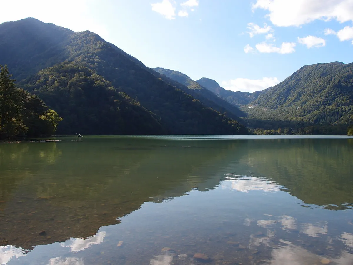
Lake Yunoko Loop
This gentle 3 km loop circles Lake Yunoko in about one hour, making it one of the easiest walks in the park. The northern shore passes close to Yumoto Onsen, where sulfurous steam vents rise from the lakebed — a visual that sets Yunoko apart from Lake Chuzenji. The trail is free, well-marked, and suitable for families with young children.
Autumn is the best time to walk this loop. The surrounding beech and larch canopy turns gold and orange from late September, earlier than the lower-elevation trails. Combine the loop with a soak at one of the Yumoto Onsen ryokans afterward — the sulfurous water is particularly good for tired legs after a day on the marshland trail.
Akechidaira Plateau
Akechidaira is the shortest rewarding hike in the park — a 1 km walk to a ridge that overlooks both Kegon Falls and Lake Chuzenji simultaneously. The trail itself is free; many visitors instead take the ropeway (1,000 yen each way) from the lower car park to the viewing platform, then skip the short walk entirely. Either way, this is the best single viewpoint in Nikko for photographers. Plan 30 minutes if you walk, or 15 minutes if you take the ropeway.
The fall foliage season transforms this spot into one of the most photographed viewpoints in Japan. Visit during the first two weeks of October for peak color at this elevation. Arrive before 09:00 on weekends — the ropeway queue can exceed 45 minutes during peak autumn weekends.
Lake Chuzenji Circumference Trail
The full circumference of Lake Chuzenji is 25 km and takes eight to nine hours — a serious full-day commitment. The route passes through deep beech forest, sacred shrines, and secluded pebble beaches that most visitors never see. There is no entry fee. The southern shore provides the quietest stretches; the northern side runs closer to the main road and picks up more traffic.
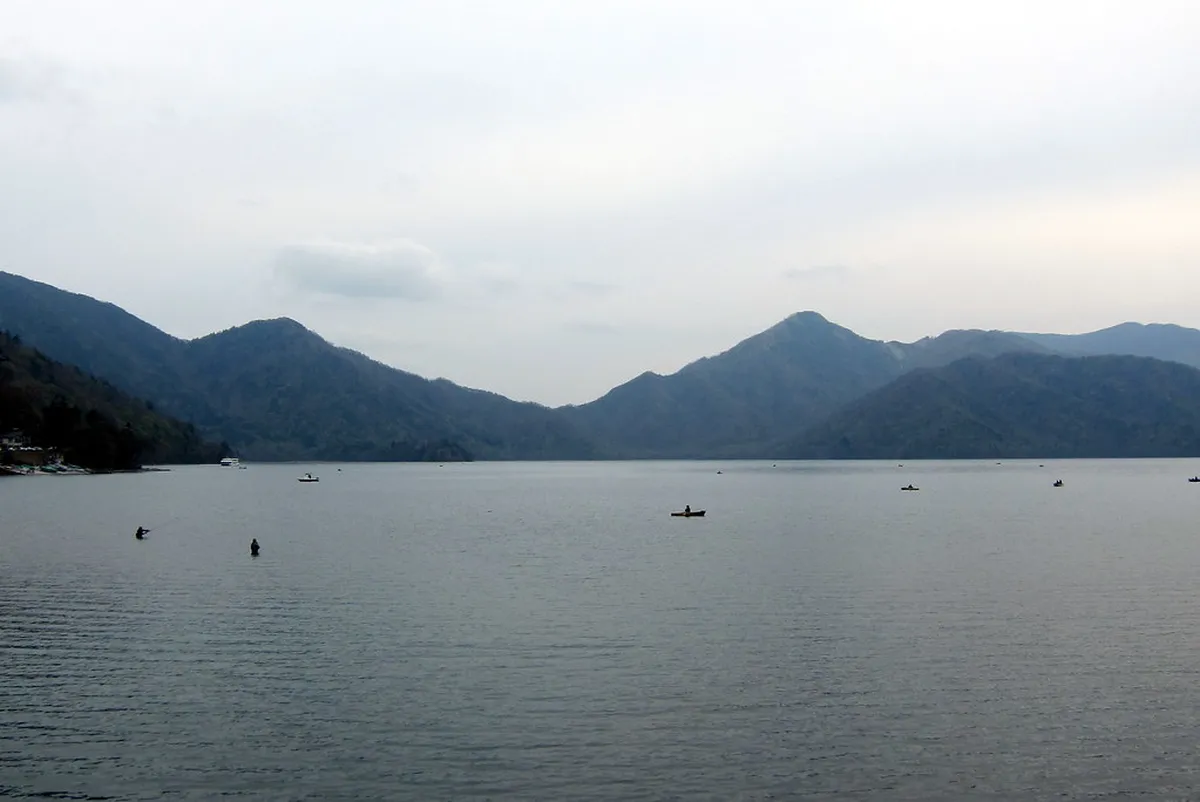
Most hikers who attempt this trail break it across two days using an overnight stay in the Chuzenji area. If you only have one day, walk the southern arc from Chuzenji Onsen to the Nantai trailhead and back — this takes four hours and covers the most scenic section. Waterproof shoes are essential; the forest sections hold mud even in dry weather.
Nikko Toshogu Shrine to Takinoo Shrine Hike
This 3.5 km stone-paved path connects the famous Toshogu Shrine complex to the much quieter Takinoo Shrine, passing through cedar forest and over ancient bridges. The round-trip takes 90 minutes and is free to walk. It is the best option for visitors who want to hike but cannot travel up to Okunikko. The path is historically significant — monks used these routes as spiritual training circuits for centuries.
The trail is accessible directly from the town center, which makes it uniquely convenient. You can finish your shrine visits by 10:00 and be on this path before the midday crowds arrive. Watch for the carved stone lanterns that line sections of the route — many date to the Edo period and are themselves part of the UNESCO heritage listing.
More Nikko Hiking Routes
Beyond the five signature trails above, the park offers a wide range of options for different fitness levels and interests. Mt. Nantai summit (6–7 hours, 1,000 yen registration fee at Futarasan Shrine, open May 5 to November 11) is the most demanding and most rewarding ascent in the area. The Yumoto Onsen to Senjogahara traverse (7.8 km, 3 hours) is a point-to-point route that starts from the hot spring village and drops through lush forest to the marshland. The Ryuzu Falls to Senjogahara path (45 minutes, free) follows the rushing Yu River and provides a good warm-up before tackling the full marsh boardwalk.
Shorter options include the Kanmangafuchi Abyss Riverside Walk (1.5 km, 30 minutes, free), which follows the Daiya River past 70 stone Jizo statues and is walkable directly from town. The Jakko Falls Forest Path (40 minutes from the bus stop) leads to a seven-tiered waterfall that sees far fewer visitors than Kegon Falls. Mt. Hangetsuyama (30 minutes from the upper car park) gives the best aerial view of the characteristic U-shape of Lake Chuzenji and is free. Kirifuri Plateau Heaven's Corridor (1,445 steps, 40 minutes, free) rewards the climb with slopes covered in yellow daylilies in late June.
For those with more days, the Mt. Nikko-Shirane trails reach the highest peak in the region via ropeway (2,500 yen round-trip) plus a five-hour summit hike. The Ashio Mountain Trail to Mt. Bizan explores the industrial reforestation history of a nearby town and is best reached via the scenic Watarase Keikoku Railway. The Odashirogahara Plateau Loop (90 minutes, free) visits the quiet meadow famous for a solitary birch known as the 'Lady of Odashiro', most beautiful when the grasses turn gold in late September. The Urami Falls Hidden Path (30 minutes) and Yudaki Falls to Kotoku Trail (1 hour, ends at a dairy farm with fresh ice cream) round out the complete 17-trail list covered in this guide.
Autumn Colors: How Elevation Changes Everything
No competitor guide explains this clearly, but Nikko's autumn foliage does not peak everywhere at once. Color moves from high to low over roughly three weeks, and understanding this lets you target peak color on the specific trails you plan to walk. At Yumoto Onsen and the Lake Yunoko Loop (around 1,475 m elevation), foliage typically peaks in the last week of September. The Senjogahara Marshland (around 1,400 m) follows in the first week of October. Akechidaira and the Lake Chuzenji area (1,270 m) hit peak color in mid-October. Nikko town itself (630 m) is at its best in late October into early November.
In practice this means a hiker who visits on October 10 can catch peak color at both Senjogahara and Akechidaira in a single day — something day-trippers who only come for the shrines in town miss entirely. If you have two days, spend the first morning at the high trails while color is fresh and the second morning at the Toshogu shrine area as the lower maples turn. Checking the official Nikko autumn color report (published annually by Visit Nikko from early October) gives you the most current altitude-by-altitude forecast for your specific travel dates.
Daytrip or Overnight at Nikko's Hot Springs
Two onsen areas serve hikers in Okunikko: Yumoto and Chuzenji. Yumoto is quieter and more remote, situated at the far end of the park near the Lake Yunoko Loop. Its water is milky and sulfurous — the classic mountain onsen experience. Most ryokans here include dinner, and prices start around 12,000 yen per person. It is the right choice if you want a true retreat after a long day on the higher trails.
Chuzenji Onsen sits closer to the lake and the main bus routes, making it easier to access without a car. The water is clear rather than sulfurous, and several hotels allow day-use baths for 1,000 to 1,500 yen. The views of Mt. Nantai from the lakeside baths are exceptional at dusk. Check where to stay in Nikko for a breakdown of both areas with current pricing. Book any ryokan well in advance for autumn weekends — these rooms sell out months ahead.
Nikko by Car — Explore Like a Local
A rental car removes the biggest constraint on Nikko hiking: bus schedules. The first buses from Nikko Station to the upper plateau don't depart until around 08:30, which means arriving at popular trailheads after the crowds. A car lets you reach the Senjogahara trailhead before 07:30 and claim one of the limited parking spaces at Akanuma before the lot fills. Most rental agencies are outside Nikko Station; expect 7,000 to 10,000 yen per day for a compact car in 2026.
Driving the Irohazaka Winding Road (48 hairpin turns, one-way uphill on Route 120) is the main challenge. During autumn peak weekends the road can see multi-hour queues from 09:00 onward. Leave before 07:00 to clear the climb before traffic builds. Gas up in town — stations are rare in the upper plateau. The Senjogahara trailhead lot at Akanuma is free but fills by 09:00 on busy weekends. The Yudaki Falls lot is smaller and fills even faster.
Rail Pass Prices and Getting to the Trails
The Tobu Railway Nikko Pass saw a price increase in late 2024. As of 2026, the All Area version (covering buses to Yumoto and Chuzenji) costs around 4,520 yen for two days; the World Heritage Area version covers only the lower zone buses. If you plan to hike in Okunikko, you need the All Area pass — the bus to Senjogahara and Yumoto is not included in the cheaper version. The JR Pass is generally not cost-effective for a Nikko day trip from Tokyo; the Tobu Line from Asakusa is faster and cheaper regardless.
The Tobu Limited Express Spacia X connects Asakusa to Tobu Nikko Station in about 110 minutes. Seat reservations cost an additional 1,070 yen on top of the base fare but are worth it on weekends to guarantee a seat. A two-day local bus pass for the Chuzenji area costs approximately 2,300 yen and covers most trail access points. For comparison, taking the bus per ride to Senjogahara and back costs about 2,060 yen — the pass pays for itself with just one round trip to the upper plateau.
Hiking Tips and Safety Guidelines
Download Yamap (Japan's standard hiking app) before you set out — mobile signal is patchy in the cedar forests between the shrines and Chuzenji. The Akanuma trailhead parking lot for Senjogahara fills by 09:00 on busy weekends; arrive before 07:30 by car or take the first bus.
The most common mistake first-time Nikko hikers make is underestimating the cold. Even in July, Okunikko runs 10–15°C cooler than Tokyo. Bring a wind layer regardless of the forecast. In winter, ice accumulates on the Ryuzu Falls stairs and along the Takinoo path — metal chain spikes (sold at the tourist information center near the station for around 1,500 yen) are necessary from late November onward. Bears are present in the park; make noise on forested trails, particularly in the early morning. Monkeys are common near Kanmangafuchi and will approach if they see food.
Wear proper hiking boots — trail shoes are fine for Senjogahara and Yunoko, but anything involving Mt. Nantai or the Shirane routes requires ankle support. Carry at least one liter of water; vending machines exist at the main trailheads but not on the trails themselves. Download an offline map (Yamap is the standard Japanese hiking app) before you set out — mobile signal is patchy in the cedar forests between the shrines and Chuzenji. Tell someone your intended route and expected return time if you are heading for any summit trail.
Mt. Nantai is open only May 5 to November 11 — trail gates are locked outside these dates. Bears are present in the park; make noise on forested trails, especially in early morning during the September–November pre-hibernation feeding window.
Mt. Nantai has a strict seasonal window: open from May 5 to November 11 only. Attempting the summit outside these dates is prohibited for religious reasons and the trail gates are locked. The Nikko-Shirane ropeway typically closes for snow maintenance from late November to late April — check the Ministry of the Environment Nikko National Park page before planning this route.
Frequently Asked Questions
Which Nikko hiking trails options fit first-time visitors?
First-time visitors should start with the Senjogahara Marshland trail. It is flat, well-marked, and offers the best scenery for minimal effort. You can easily combine it with a visit to the nearby waterfalls.
How do I get to the Senjogahara Marshland from Nikko Station?
Take the Tobu bus bound for Yumoto Onsen from outside Nikko Station. Get off at the Sanbonmatsu or Akanuma bus stop after a 50-minute ride. The trailhead is located directly across from the bus stops.
Is Nikko hiking worth including on a short itinerary?
Yes, hiking is worth it even on a one-day trip if you focus on one specific area. A morning at the shrines followed by an afternoon walk at Kanmangafuchi Abyss is very manageable. This allows you to experience both culture and nature.
The Nikko hiking trails offer a profound connection to Japan's natural and spiritual heritage. From the misty shores of Lake Chuzenji to the rugged peaks of the interior, there is a route for everyone. We hope this guide helps you plan an unforgettable adventure in one of Japan's most beautiful national parks.
Remember to check the best time to visit Nikko to align your hike with the seasons. Whether you come for the summer cool or the autumn colors, the mountains are waiting. Safe travels and enjoy every step of your journey through these ancient woods.
Free: The Nikko Essentials guide
Top things to do, where to stay, a perfect day plan, getting around, and the best time to go — a Nikko mini-guide you can take offline.
You might also like


Continue reading
More guides you'll find useful